 Your Mission…
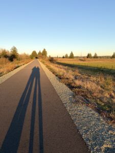
Describe the unique ecosystems on each side of the trail. What differences do you notice between the two sides? What is similar? (Think about plants, trees, sunlight, soil, wildlife, and how the land feels. Be specific about what you observe.)
Hint: To the west side of the trail, the land rises toward the Black Hills and is more forested. To the east, you’ll find a prairie landscape that is unique to this part of Washington state.
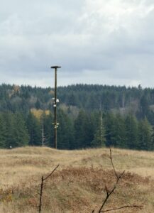
Bonus challenge:  What evidence do you see that you’re on an old railroad corridor?
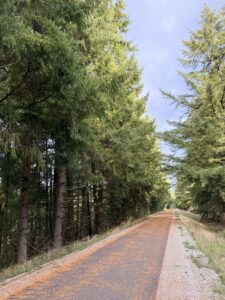
The Gate–Belmore Trail follows an old railroad line through southwest Thurston County. It winds through farmland, prairie, forest, and wetlands–and connects nearby communities. It is also part of a growing regional trail network that will link even more places in the future.
KNOW BEFORE YOU GO
- Dogs are welcome–please keep them on a leash to protect wildlife, habitats, and other trail users. And be sure to pick up after your pet!
- Parking is available at the trailhead. The trail is paved, wide, and gently graded, making it an accessible place to walk, bike, and enjoy nature.
Additional Information
 The Gate-Belmore Trail follows the old BNSF railway line built in the 1890s in southwestern Thurston County. It is named after two former train stops–Gate and Belmore. In 1996, Thurston County acquired the corridor with the goal of turning it into a shared-use trail and eventually linking it to other regional trails.
For many years, the trail had limited public access and improvements. In July 2025, a 2.7-mile paved section near the Glacial Heritage Preserve area opened, making the trail safer and easier for people to use
Gate-Belmore is part of a long-term plan to connect more than 50 miles of regional trails. Future trail plans focus on connecting popular places like Kenneydell Park, the Black River National Wildlife Refuge, and the nearby Mima Mounds area.
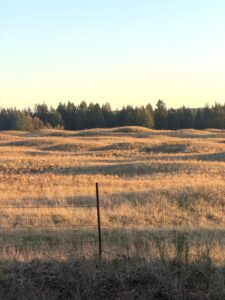
For thousands of years, Indigenous peoples (including the Squaxin Island Tribe and other Coast Salish communities) cared for the South Sound prairies. These grasslands weren’t empty or wild by accident. People used controlled fire to keep trees from taking over and help important foods like camas grow. The prairies were places to gather food, hunt, and travel. They were part of a thoughtful system of caring for the land based on close knowledge of the seasons.
Click on the following links to learn more about South Sound prairies:
Westside Prairie (WA Department of Fish and Wildlife)
South Sound Prairies (Center for Natural Lands Management)
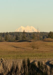
Fun Fact:
On a clear day, you can see Mount Rainier to the northeast. The Puyallup Tribe calls the mountain Tahoma, meaning “mother of waters.”
 Trail History – Then and Now
Long before it was a trail, Gate-Belmore was a railroad line that helped build southwest Thurston County. In the 1890s, trains carried people, timber, and supplies through these forests and prairies.
Today, that old rail line is a trail — a place to walk or ride, connect with neighbors, and slow down to notice the natural world around you.
Questions to explore:
- Can you find a place where the trail is unusually straight or level? (That’s a clue you’re walking on old railroad corridor.)
- Do you see gravel or raised ground? Imagine locomotives running here over 100 years ago!
Fun Fact:
You can still see parts of an old apple orchard north of the trailhead parking area. Today, WA state is home to more than 30 different kinds of apples!
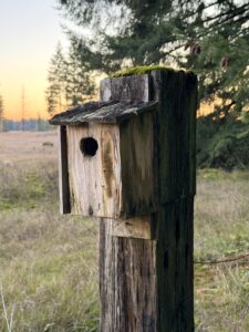
Local Wildlife Habitat
This trail passes through a variety of diverse habitats — forests, wetlands, and prairie.
Look for:
- Different kinds of trees. How many types of trees can you find?
- Birds, like bluebirds or osprey. What habitat do they prefer here?
- Insects, butterflies, or pollinator-friendly plants. Do you see evidence of pollinators? What? Where?
Check out the links below for additional information:
 Douglas Fir Tree
Western Red Cedar
Oregon White Oak
Western Bluebird
Taylors’ Checkerspot Butterfly
Osprey
Wetland and Water Clues
Look around–you’re standing in the Black River watershed. That means the rain that falls here eventually flows north to the Black River. Even if wetlands or ponds look dry today, they still play an important role. When it rains, they slow the water down, let it soak into the ground, and filter it before it continues downstream.
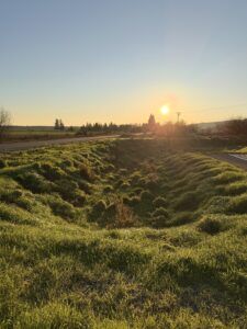
As you walk, look for low spots along the trail where wetland plants grow. Pause for a moment to really notice what’s around you.
Questions to explore:
- What clues show that water collects here after it rains?
- How do plants in wetter areas look different from those in drier spots?
- How might slowing water here help protect the river downstream?
Fun Fact:
The stormwater pond near the trail parking area helps capture and filter runoff from the pavement. This helps keep oil, metals, and other pollutants out of our nearby streams and wetlands!
 Culture and Stewardship
The land you’re walking on has been home to people for thousands of years. Indigenous communities lived here and cared for this place long before it became a railroad or trail. Later, settlers used the land in new ways. Today, it’s cared for by planners, volunteers, and community members.
As you walk, think about how this place has changed– and how people continue to shape and care for it.
Questions to explore:
- Where do you notice signs that people shaped or cared for this land?
- How might a trail like this help people feel more connected–to nature and to each other?
Did you know?
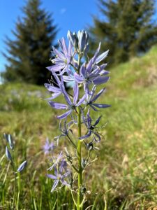
In Thurston County’s prairies, camas blooms in late spring with tall stems and bright blue-purple flowers. Underground, the plant grows a bulb that was an important food for Indigenous peoples, including the Squaxin Island Tribe and other Coast Salish communities. The bulbs were carefully dug up and slow-cooked in underground ovens, which made them sweet and filling. Camas could be eaten right away or dried and traded with other communities.
Don’t Let Your Pooch Pollute!
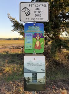
How can you help maintain good water quality at the Gate-Belmore Trail while using the trail?
Don’t let your pet pollute! Pet waste can wash into our waterways, adding bacteria and nutrients that pollute water and can harm people, fish, and wildlife.
Help protect our waters and pick up after your pet! Scoop it, bag it, and trash it—every time! Even in wetlands, in forests, and on the prairie!
Why This Place Matters
From a 19th-century railroad route to 21st-century trail, Gate–Belmore is a story of connection. It connects the past to the present, and people to place.
Trails like this invite people outdoors, support recreation and conservation, and help protect habitats and waterways in Thurston County.
Happy exploring!
Can you use what you learned today in other places you visit? Nature is connected everywhere—even where you live. Next time you go for a walk near your home, look around and notice the plants, animals, and any nearby water. What small actions can you take to help protect those places?